Simulations of rain-on-snow events are performed using tools developed by the Western Consortium for Watershed Analysis, Visualization and Exploration (WC-WAVE). WC-WAVE is a collaborative program among researchers from many different disciplines in Idaho, Nevada, and New Mexico that seeks to create a Virtual Watershed simulation to more efficiently model and understand actual watershed dynamics.
This research will help in understanding the hydrology of mountain watersheds. It will also help to understand and predict the impact of snow transitioning to rain due to a changing climate. Early results indicate that more frequent low-snowfall years in the future could significantly affect water resource availability, thermal and biogeochemical processes in soil, and ecosystems as a whole.
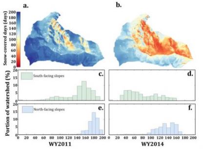
New approaches to simulating the impact of mid-winter rain on top of snow in mountain watersheds in southwest Idaho are providing insights into the timing and availability of water resources. Results are providing a better understanding of the relationship between the distributions of snow and melt water to elevation, vegetation, and more.