The adoption of the GSToRE platform leverages previous NSF EPSCoR investments in the development of this flexible and scalable data management platform, which accelerates the integration of improved data management capabilities into the watershed science work at the core of the WC-WAVE project. Additional enhancements to the platform will both increase its utility in other projects, but also broaden its developer base through the collaborative work of the teams in all three WC-WAVE states: Idaho, Nevada, and New Mexico.
The project’s virtual watershed platform allows for the unified management of diverse tabular, geospatial and file-based data and associated documentation. It also provides access to these data through a number of web-accessible services. These services will enable efficient access to the data required to run watershed-scale models, rapid integration of model outputs into the system for discovery and reuse, and dynamic visualization of all of the data related to a given watershed.
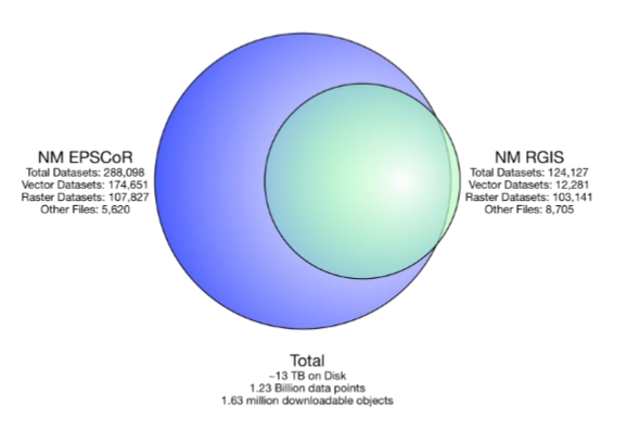
The Western Consortium for Watershed Analysis Visualization and Exploration (WC-WAVE) project is advancing watershed science through data intensive modeling and visualization. The Geographic Storage, Transformation and Retrieval Engine platform (http://gstore.unm.edu) is the foundation for the project’s virtual watershed platform used to provide data discovery, access and publication capabilities. The GSToRE platform has proven to be flexible and scalable as recently demonstrated by hosting over 290,000 individual datasets, representing over 1.13 billion individually accessible datapoints. These datapoints are deliverable as over 1.6 million separate downloadable data files in multiple formats for each dataset. The current data collection provides data to two applications: New Mexico’s Resource Geographic Information System (http://rgis.unm.edu) and the New Mexico EPSCoR Data Portal (http://nmepscor.org/data_portal/browse-data). The new virtual watershed platform developed for the WC-WAVE project will be able to use any data currently stored in the GSToRE system while also accommodating new data acquired for and generated by the project.